REPUBLIC OF AZERBAIJAN
General Information
Location: The Republic of Azerbaijan lies in the borderlands of Asia and Europe. It is situated in the south‑eastern part of the Southern Caucasus and shares borders in the north with the Russian Federation, in the south with the Islamic Republic of Iran, in the west with Turkey, Georgia and Armenia and in the east its neighbours across the Caspian Sea are Kazakhstan and Turkmenistan.
Country Name: Azərbaycan Respublikası (Republic of Azerbaijan)
Capital: Bakı (Baku)
State Language: Azerbaijani
Religion: Religion is separated from the State and all religions are equal before the law
Monetary Unit: Manat
THE STATE SYMBOLS OF REPUBLIC OF AZERBAIJAN
THE NATIONAL FLAG
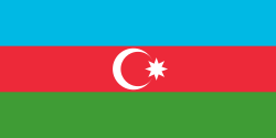 The Flag contains three horizontal stripes of equal width. The upper stripe is of blue color, the middle one is red and the lower is green. The blue color is the color of Turkic (Azerbaijani) ethnos, red color symbolizes the adherence to freedom, democracy and human rights, and the green is the color of Islam. There is a white crescent and eight-pointed star in the middle of the red stripe. The star is the reflection of the eight different branches of the Turkic people. The proportion of the width and length is 1 to 2.
THE NATIONAL EMBLEM
The star, also seen in the flag, has the same meaning of the eight different branches of the Turkic people. This eight-pointed star framed by gold, is superimposed on three circles: the inner one is green, the middle one is red, and the outer one is blue. These colors match the flag colors. Between each star point, on the blue circle, there are also smaller gold-framed eight-pointed stars. Inside the main central star there is a fire. The fire recalls the country's other name: Land of fire. This fire symbolizes also freedom. The shield stands on a golden ear of corn (not shown above).
THE NATIONAL ANTHEM
 | Music by Useir Hajibayov Words by Ahmad Javad Azerbaijan, Azerbaijan! You are the country of heroes! We will die so that you might be alive! We will shed our blood to defend you! Long live your three-colored banner! Thousands of people sacrificed their lives You're become the field of battles. Every soldier fighting for you has become a hero. We pray for your prosperity, We sacrifice our lives to you. Our sincere love to you Comes from the bottom of our hearts. To defend your honor, To hoist your banner, All the young people are ready. Glorious motherland, Azerbaijan, Azerbaijan! |
January 1 - New Year
March 8 - Women's Day
March 20-21 - Novruz Bayramı (Celebration of Spring)
May 9 - Day of Victory over Fascism
May 28 - Republic Day
June 15 - National Salvation Day
June 26 - Armed Forces Day
October 18 - National Independence Day
November 12 - Constitution Day
November 17 - National Revival Day
December 31 - Day of Solidarity of Azerbaijanis throughout the World
Qurban Bayramı (Thank-Offering Day) and Ramazan Bayramı (End of Fasting) – The dates of the celebration of these religious holidays are changed every year in accordance to the moon calendar.
Area: 86,6000 sq km
Bordering Countries: Georgia - 480 km, Iran - 756 km, Russia - 390 km, Turkey - 13 km, Armenia - 1007 km,
Administrative Division Autonomous Republic
Naxçıvan Muxtar Respublikası (Nakhchivan Autonomous Republic)
GEOGRAPHY
Azerbaijan occupies the southeastern part of the Greater Caucasus range descending to the Caspian Sea at the stretch of 800 km. The country has a unique geographical position, lying on the juncture of Europe and Asia and retains its significance for world economic and cultural links.
Azerbaijan is surrounded by mountains, occupying more than half of its territory: to the north is the Greater Caucasus with the highest peak of the country Bazar-dyuzy – 4480m (its southeastern part reaches Azerbaijan), to the southwest is the massive Transcaucasian upland extending to Armenia and Georgia, mounted by the Lesser Caucasus, to the south the Talysh Mountains join them. In the west beyond the boundary of Azerbaijan, the Greater Caucasus and Lesser Caucasus are bound by Likh (Suram) range and that part of Azerbaijan’s territory is occupied by the vast Kur-Araz lowland. It is edged with sloping valleys and lowlands. Thus, the surface of Azerbaijan resembles a gigantic tray with sharp mountainous edges, sloping to the Caspian Sea.
The exceptions to this description are the four isolated valleys: one is on the northern slope of the Greater Caucasus (Gusar valley and Samur-Davachi lowlands), another is inside the Transcaucasian highland, (Arazyani valley of Nakhchivan), the third is on the Apsheron Peninsula descending far to the sea and the fourth is Lankaran lowland at the foot of the Talysh Mountains. These most striking features of the surface along with peculiarities of geographical position profoundly determine the diversity and bounties of its unique nature, comprising the features of the Caucasus and Middle Asia. The summer for the better part of the valleys is long, dry and hot; landscape is semi-desert, partially in salt marshes it is even desert. It rains only in cold months, agriculture without irrigation is impossible. In the mountains, steppes and thin forests go along with plentiful, broad-leaf forests. On Greater and Lesser Caucasus a lot of rivers flow from mountains to valleys. Larger rivers cross them while smaller rivers dry out, falling into a range of springs, creating "dry deltas", that flowing together form a line of an oasis so convenient for settling and farming. The main contrasts in the nature of Azerbaijan come from divergences between humid mountains and dry plains and between some separate high zones. The landscape varies from dry, hot or semi-humid subtropics to snow-capped highlands and glaciers. It is worth pointing out the originality of Azerbaijani nature, bound with the influence of certain local conditions on the general landscape, determined by its geographical position.
The present panoramic view of Azerbaijani relief with its high mountains, volcanic highlands, deep canyons and river fields, valleys and coastlines with various mineral resources has been forming for millions of years of geological history. Diverse and curiously cut relief of present day Azerbaijan has peculiar characteristics of large regions.
The border of Azerbaijan with the Russian Federation (Dagestan) stretches along the ridges of the watershed ranges of Greater Caucasus in the northeast. In the northwest of the country the watershed ranges sharply descend into Alazan-Agrichay valley. To the east of Bazar-dyuzu - the highest peak of the Eastern Caucasus - both slopes of watershed ranges belong to Azerbaijan. Here on the watershed range between Bazar-dyuzy and Babadag (3629 m) high mountainous relief prevails.
The Watershed range goes along with the ruggedness of the Lateral range with highest peak Shahdag (4243 m). To the east and south-east of Babaduz, the Greater Caucasus rapidly descends and turns into fan shaped branches of mountains of medium height called Dyubrar. To the southeast they are attached by hills and low mountains of Gobustan, to the east valleys of low plateau of Apsheron Peninsula. Both of these regions are full of active mud volcanoes.
The Kur valley entirely belongs to Azerbaijan, except for its northwestern part, stretching to Georgia. This part becoming narrow in the northwestern part of the valley is separated by Middle Kur highland into two valleys - Alazan-Agrichay in the north and Ganja-Kazakh in the southwest. The Kur-Araz lowland, which like the Caspian lies entirely below ocean level, is bounded by hills and sloping valleys. On the west, at the foot of the Lesser Caucasus, the Karabakh and Mil plains descend to it on the north at the foot of the Great Caucasus - Shirvan plain. The banks of the Araz and Kur make Mugan plain extending to Iran. The Salyan plain and southeastern Shirvan stretch to the mouth of Kur. Not far from the Caspian coastline, archipelagoes of mud volcano isles emerge from the water, namely the Apsheron archipelago near the Apsheron Peninsula and the Baku archipelago near the coasts of Gobustan and the Kur-Araz lowland.
The southeast of the Lesser Caucasus is within the bounds of Azerbaijan. It is a system of several highlands exceeding 2,000-3,000 m. in height and a range of spurs of medium and low heights. Approximately in the middle the Terter river vale separates the Azerbaijan part of the Lesser Caucasus into two parts - northwest and southeast. The first is formed by a gentle arc of two ranges - Shahdag with Ginaldag peak (3367 m) and Murov dag with Gyamish peak (3725). Both slopes of Murovdag belong to Azerbaijan and the borders between Azerbaijan and Armenia pass on watershed of Shahdag range. To the southeast of the Lesser Caucasus rises the Karabakh range with Boyuk Kir peak (2725 m). It towers above the Karabakh plain and surroundings of Khankandi. In the south the mountains change from the Geyan steppe to the hilly valleys of Araz. The interiors of Transcaucasian highlands extend far into the territories of Georgia and Armenia and stretch with two small areas into Azerbaijan. To the east of this jut is the Karabakh volcanic highland covered with drift and a series of young but extinct volcanoes. Some high points are over 3,000 m (Ishikhli mount is 3552 m), though 1,500-2,500 m are more usual. On the territory of Nakhchivan the bordering highland ranges - Zangazur and Daralayaz are rising. The top of Zangazur range - Kaputjukh mountain (3,904 m) is the highest non- volcanic point of Transcaucasus highlands. The south bottom of the Zangazur ranges are washed by the Araz. The Talysh mountains are of medium height. Their highest point Kyumyurkey mount is 2,477 m. The most northeastern slopes of these mountains are in Azerbaijan. They are divided into three parallel chains by valleys and hollows. The main watershed creates the boundary of Azerbaijan and Iran so the Talysh slopes entirely lie in Iran.
Some of rivers of Azerbaijan pour into the Kur river, others flow at first into the Araz, its largest branch, still others run straight to the Caspian Sea. Annual flood of rivers is estimated 7.78 billion cm. The distribution of river net over the territory is uneven. On lowlands with mellow soil permeable to water they are rare but in mountains the number of rivers increases due to abundant rainfalls and relief. The river net is well developed on 1,000-2,500 m heights. Generally, there are 90,000 cub.m of drain per 1 sq.km, that makes 1,270 cub.m per capita. The biggest river in Azerbaijan is the Kur. It is 900 km long within Azerbaijan. The Araz flows into Kur 236 km off its mouth. The Kur forms a delta at its mouth which is 15 km. long. It is drains into Caspian through two branches: northeast, now shoaled and southeast. A navigable one was dug in 1964 in southeastern direction. The second river in size is the Araz which gathers its waters like the Kur in Turkey. It is 1072 km. long. It makes a natural boundary between Azerbaijan, Turkey and Iran along 580 km. stretch. On the territory of Nakhchivan the river has some branches: the East Arpachay, the Nakhchivan, the Alindjachay, the Gilanchay. After the Acer river joins it, it reaches the Kur-Araz lowland. In the mountains there are several thousands of small rivers less than 10 km. long. About 800 rivers of the Republic are from 10 to 100 km. long. 23 rivers are over 100 km. long. General resources of river waters of Azerbaijan including the drains of transit rivers bringing waters from neighboring territories constitutes 30 cubic km. per year. Mountain rivers flow to the valleys large masses of soil and stones often in catastrophic streams, which cause great damage to agriculture.
Potential hydropower resources of Azerbaijan rivers make 16 billions kw/hour in a year. The main share of which goes to the Kur and Araz rivers. The rivers of the Greater Caucasus have large resources of hydro-energy due to their sharp falls. The main hydropower stations - Mingechevir (the biggest in Transcaucasus) and Varvarin are working on the Kur. Only the Kur is important for transportation. The part of the Kur from Yevlakh to its mouth is navigable for small passenger and cargo vessels. The rivers are valued as fishing farms. Here salmon and sturgeon are caught. In the rivers of the Lesser Caucasus trout is found. The number of small lakes in Azerbaijan is about 250. The lakes in mountains are of tectonic and glacial origin: Goy-gol (at 1,556 m height), Big and Small Alagel (at 2,730 m height). Along the Caspian coast there are the lakes - Devechi, Gemushovan, Gil, Kildag. Binagadi Kir lake on the Apsheron is unique and is the place of mass burial of ancient animals. Along with natural hydro geographical net in Azerbaijan the system of irrigation acts that is regulated by water reservoirs. The largest is in Mingechevir, built in 1953. The weir of 88 m. height forms a water reservoir of 605 sq. km. and by the volume of 16.1 million cub. km. Araz (volume of 1.35 million cub. m.) Shamkhor (2.67 million cub. m.). The irrigating canal takes its beginning from the first reservoir - the Upper Karabakh and the Upper - Shirvan canals. They take their waters to cotton fields of Kur - Araz lowlands. The thickest net of canals of irrigation system is formed on Mughan valley. The total stretch of all canals exceeds 3000 km. On Samur-Devechi lowland the Samur-Devechi irrigation canal passes 191 km. long, that takes its origin from the Samur river up to Jeyranbatan water reservoir, that extends along the Apsheron Peninsula. The waters of this canal not only irrigate dry lands of northwest of Azerbaijan and Apsheron but meet the needs of the population and industry of Baku and Sumgayit. The length of the canals in the Republic is 47,058 km, and 1.4 million hectares of irrigated area.
Underground waters used in agriculture of Azerbaijan are of importance in water supply of some districts. They are a bit salty in Apsheron. The Caspian Sea is the largest salty lake on the earth. But its size and hydrological characteristics and origin give ground to call it a sea. In its geological past the Caspian had been connected with world oceans in the west and in the north. Some facts of paleontology as well as the species of fauna preserved in Caspian (15 types of shellfish and fish represent cold water fauna) refer to the links of the Caspian sea with the North seas.
The soils surface of Azerbaijan has a spectrum of types from mountain - meadow soils of Alpine highlands to dry sands of semi-deserts and yellow earth of Lankaran subtropics. This variety was provided by complex geological structure relief, hydro-climatic conditions and vegetation. The farming industry has also influenced the shape of soil of Azerbaijan.
The soil of the oasis bears the impact of land farming. It is subjected to intensified washing under conditions of artificial irrigation (often to a second salting), significantly enriched with fertilizers and became the element of cultivated landscape. They are affected by doubled irrigation (at times twice the salinity) and are fertilized. Beneath mountainous forests and steppes is highly fertile black earth. A peculiar type of soil, yellow, is viewed in the Talysh and Lankaran regions. The abundance of warm and humid air intensively drives away chemicals and the soil in the upper layers concentrates in itself ferrous oxide and alumina and acquires a yellow color changing into orange.